First, A Little History
When I first visited the area around Folsomville in the mid 1990's with my cousin Ray Junior Austill
we took a trip down Nickens Road past a road known as CR625N. However until the last few months I never realized it was
also named Austill Rd.
Thanks to Google Maps I made this discovery and thanks to Google Maps street-view I had made an on-computer trip down this road and even viewed the signs which now say Austill Rd (as well as CR625N).
In mid-June (2009) My daughter Joanna and I had the opportunity to meet some of our cousins
in Warrick County and Evansville. During our visit we took a trip to the Folsomville area including Austill Road.
Austill Rd is about 3/4 mile south of the Boonville-Folsomville Rd. It runs between Ellis Rd and Nickens Rd
(Nickens Rd is about 1 mile west of Folsomville)
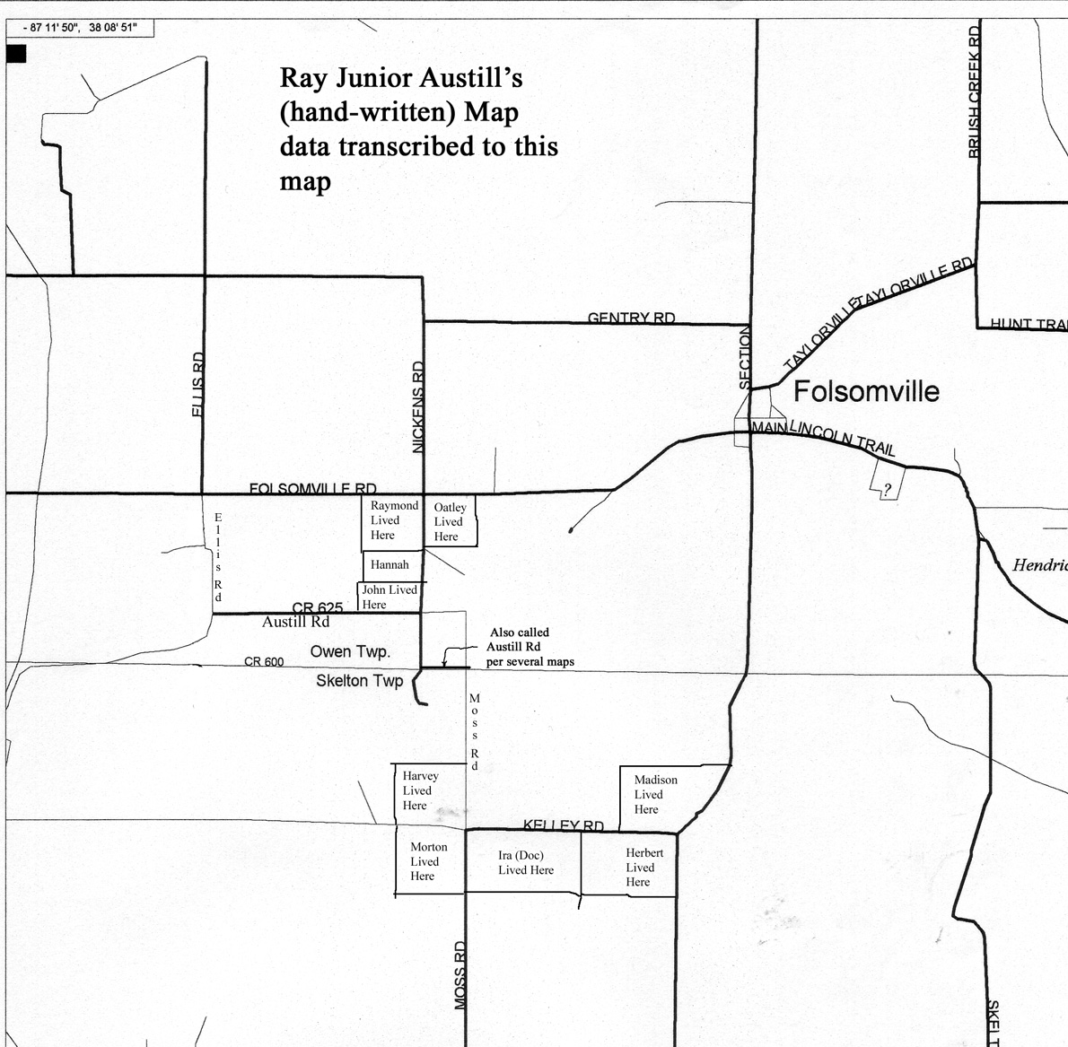
(click on image for larger version)
A transcription of a hand-drawn map given to me by
my cousin Ray Junior Austill
(son of Ira (Doc) Austill & Rosella Myrtle (Hill) Austill)
On the map are the locations which Ray remembered where some members of the family lived when he was living there
You should be able to find Austill Rd on the map also
I decided to make a photographic record of our trip west-to-east beginning at Ellis Rd. Those photos appear below
(click on image for larger version)
Here we begin the trip at the corner of Austill Rd & Ellis Rd.
(click on image for larger version)
Still at the corner of Austill Rd & Ellis Rd, looking south-easterly
(click on image for larger version)
Still at the corner of Austill Rd & Ellis Rd, looking north-easterly toward Folsomville, you can see the Folsomville water-tower
(click on image for larger version)
Still at the corner of Austill Rd & Ellis Rd, looking due east, down Austill Rd.
(click on image for larger version)
A little east of Ellis Rd, looking toward the south we spotted several wild turkeys down in the field
(click on image for larger version)
Another look at the turkeys down in the field
(click on image for larger version)
Continuing east
(click on image for larger version)
(click on image for larger version)
About half-way to Nickens Rd
(click on image for larger version)
(click on image for larger version)
(click on image for larger version)
If you look closely you can see the "Austill Rd Squirrel" running away from us
(If I'd have been quicker you would be seeing a picture of him looking at us!)
(click on image for larger version)
(click on image for larger version)
Going through a "tree tunnel"
(click on image for larger version)
(click on image for larger version)
(click on image for larger version)
Almost to Nickens Rd
(click on image for larger version)
Here's the whole crew (l-to-r)
Cousin Ruth, Cousins Janet & Pam (Janet & Pam are sisters), Cousin Dave (editor of this web-site), my daughter, Joanna
(We are standing at the corner of Austill Rd & Nickens Rd)
(click on image for larger version)
Ruth, Janet, Pam, & Joanna
(According to Ray's Map (above) the area in the background would be where John Austill lived)
(click on image for larger version)
The south end of Nickens Rd, about 1/4 mile south of Austill Rd, we are going to turn left here
(click on image for larger version)
The road sign calls this short section of road Moss Rd, but several maps
(including Google Maps) call it Austill Rd, also.
(It is very close to being on the township-line between Owen & Skelton Townships)